R.I.P. Robert Molner, founder of Wide World of Maps, Inc.
Mogollon Rim Country (Arizona) Topographic Wall Map Poster [Gift] Diaz
Adventure iDiaz Maps
$ 59.95
Davis Dam Surface Management Status 1:100,000-Scale Topographic Map (Arizona 60x30-Minute Quadrangle)
United States Department of the Interior
$ 20.95 $ 15.95
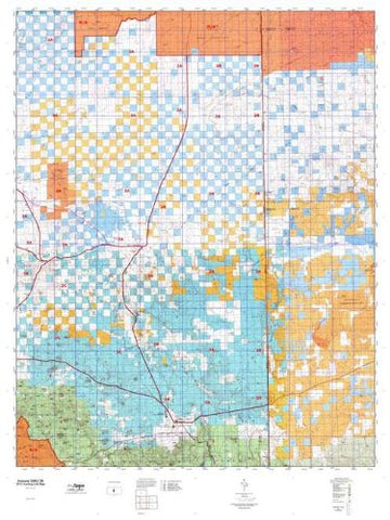
Arizona GMU 02B Hunt Area / Game Management Unit (GMU) Map
MyTopo
$ 36.95
Fort Huachuca Surface Management Status 1:100,000-Scale Topographic Map [Map] Bureau of Land Management, Arizona State Office
$ 19.95 $ 15.95
MOUNT HOPKINS, AZ 7.5' 1981 [Map] United States Geological Survey
Wide World Maps & MORE!
$ 12.95 $ 9.95
MOUNT FAGAN [Map] United States Geological Survey
$ 20.95 $ 12.95
Baldy Mountain, Arizona 7.5'×7.5' [Map] United States Geological Survey
MCNARY [Map] United States Geological Survey
McLellan Reservoir, AZ [Map] United States Geological Survey
Lone Butte 7.5' UST [Map] United States Geological Survey
Lone Butte, Arizona 7.5'×7.5' 1973 [Map] United States Geological Survey
Lake Montezuma, Arizona [Map] United States Geological Survey
$ 18.95 $ 12.95
KINNIKINICK LAKE, AZ [Map] United States Geological Survey
Kayler Butte, Arizona 2004 (7.5'×7.5' Topographic Quadrangle)
KAISER SPRING, AZ 7.5' 1980 [Map] United States Geological Survey
$ 20.95 $ 9.95
HUALAPAI PEAK [Map] United States Geological Survey
$ 9.95
Huachuca Peak, Arizona 1996 (7.5'×7.5' Topographic Quadrangle) [Map] United States Geological Survey
HORNER MTN, AZ 7.5' 1967 [Map] United States Geological Survey
ASH FORK, AZÊ7.5' 1979 [Map] United States Geological Survey
$ 18.95 $ 9.95
Helvetia 7.5' AZ 1996 [Map] United States Geological Survey

 As Seen On TV


![MCNARY [Map] United States Geological Survey - Wide World Maps & MORE!](http://wide-world-maps-more.myshopify.com/cdn/shop/files/873_large.jpg?v=1744301141)


![KAISER SPRING, AZ 7.5' 1980 [Map] United States Geological Survey - Wide World Maps & MORE!](http://wide-world-maps-more.myshopify.com/cdn/shop/files/727_large.jpg?v=1744301219)


![HORNER MTN, AZ 7.5' 1967 [Map] United States Geological Survey - Wide World Maps & MORE!](http://wide-world-maps-more.myshopify.com/cdn/shop/files/674_large.jpg?v=1744301247)
![ASH FORK, AZ 7.5' 1979 [Map] [Jan 01, 2017] United States Geological Survey - Wide World Maps & MORE! - Map - Wide World Maps & MORE! - Wide World Maps & MORE!](http://wide-world-maps-more.myshopify.com/cdn/shop/products/41lK0R0mDZL._SL1000_6defc27c-1efc-42b6-a2a3-412bdb641385_large.jpg?v=1744301250)
